Annotated corpora, provided that they adopt international standards and expose data in
open format, have many more chances to be easily exploited and reused for different
objectives than traditional, analogue corpora. This paper aims at presenting the results
of the early adhesion to best practices and principles afterward codified as Open
Science and FAIR principles in the frame of projects concerned with digital textual
corpora, in a niche area of research such as the pre-Islamic Arabian epigraphy. The case
study analysed in this paper is the Digital Archive for the Study of pre-Islamic Arabian
inscriptions – DASI, an online annotated corpus of the textual sources from Ancient
Arabia, which also exposes its records in standard formats (oai_dc, EpiDoc, EDM) in an
OAI-PMH repository. The initiatives of reuse of DASI open data in the frame of the
recently ANR-funded project Maparabia (CNRS-CNR) are discussed in the paper, focusing on
the exploitation of DASI’s onomastic and geographic data in a new reference tool, the
Gazetteer of Ancient Arabia. After introducing DASI and Maparabia projects and
highlighting the objectives of the Gazetteer, the paper describes the conceptual model
of its database and the module importing data from DASI. The population of the
Gazetteer, implying also a data entry and manipulation phase, is exemplified by the
case-study of the Ancient South Arabian place ‘Barāqish/Yathill’. Based on the above
experience, limitations and opportunities of data reuse and synchronisation issues
between systems are discussed.
I corpora annotati, a condizione che adottino standard internazionali ed espongano i
dati in formato aperto, hanno molte più possibilità, rispetto ai corpora tradizionali e
analogici, di essere riutilizzati per obiettivi diversi da quelli per cui sono stati
concepiti. Il presente articolo intende presentare i risultati di una precoce adesione
alle buone pratiche e ai principi successivamente codificati come Open Science e FAIR
nell’ambito di progetti di corpora testuali digitali, specificamente in un campo di
ricerca che possiamo definire di nicchia, ovvero l’epigrafia dell’Arabia preislamica. Il
caso di studio analizzato in questo articolo è il Digital Archive for the Study of
pre-Islamic Arabian inscriptions - DASI, un corpus online annotato delle fonti testuali
dell’Arabia antica, che espone i suoi record anche in formati standard (oai_dc, EpiDoc,
EDM) in un repository OAI-PMH. L’articolo presenta le iniziative di riuso dei dati
onomastici e geografici di DASI in un nuovo strumento di reference, il Gazetteer of
Ancient Arabia, sviluppato nel quadro del progetto Maparabia (CNRS-CNR) recentemente
finanziato dall’ANR. Dopo un’introduzione ai progetti DASI e Maparabia, in cui sono
esposti gli obiettivi del Gazetteer, l’articolo descrive il modello concettuale del suo
database e il funzionamento del modulo di importazione dei dati da DASI. Il popolamento
del Gazetteer, che implica anche una fase di inserimento e manipolazione dei dati, è
esemplificato dal caso di studio del sito sudarabico di ‘Barāqish/Yathill’. Tale
esperienza offre un’occasione per discutere delle limitazioni e delle opportunità di
riutilizzo di dati e metadati testuali, e delle questioni relative alla sincronizzazione
fra sistemi.
Introduction
Building large, annotated textual corpora is hard-working, time consuming and expensive.
Moreover, work and skills gained by researchers committed to this activity are still
scarcely acknowledged by the academic community. However, annotated corpora, provided
that they adopt international standards and best practice, and expose data in open
format, have many more chances to be easily exploited and reused for different
objectives than traditional, analogue corpora (). This
paper illustrates this thesis by focusing on the potential of the open-access archive of
pre-Islamic Arabian inscriptions DASI, which is the main source of data for a different
and further reference tool, the Maparabia digital Gazetteer of Ancient Arabia.
The first part of the article presents the project Maparabia and the DASI archive. The
central paragraphs describe the Gazetteer system, i.e. its conceptual model and
architecture, critically discussing opportunities and limitations in the reuse of DASI
data within the Gazetteer. The case-study of the ancient South Arabian place of
‘Barāqish/Yathill’ exemplifies the functioning of the tool and the choices operated in
its design. The paper ends with a focus on the challenges faced and the solutions
devised in the synchronization of data between DASI and the Gazetteer.
DASI archive: A source of onomastic and geographic data
Over the past years, considerable advancements have been made in the research on
Ancient Arabia, leading to the production of a mass of archaeological and textual data.
The epigraphic databases have played an outstanding role in disseminating this knowledge
through the web publication of tens of thousands of annotated inscriptions and graffiti,
spanning 1,500 years of history and covering a region that had long remained at the
margins of the Near Eastern studies.
DASI - Digital Archive for the Study of pre-Islamic Arabian Inscriptions is an online archive publishing at present the curated edition of nearly 8,500
inscriptions from Ancient Arabia (). DASI corpus is for the
most part made of the epigraphic heritage of the Ancient South Arabian civilization,
which flourished since the early 1st millennium BCE until the advent of Islam, in the
region corresponding to modern Yemen and neighbouring areas (the classical Arabia
Felix) (). The Ancient South Arabian textual
heritage is composed by over 10,000 inscriptions and graffiti, and hundreds of texts on
wooden sticks ().
The information encoded in DASI primarily regards the epigraphic texts. Annotation of
the textual phenomena is made according to the TEI-EpiDoc schema () in an XML encoding module embedded into the database. In
DASI, the textual annotation concerns transcriptional, philological, and linguistic
information – with a focus on onomastics. Names are essential components of an
epigraphic source as they provide direct information on individuals and historical
personalities, on the components of society, on divine figures, on places of the natural
and anthropic space, etc. Names, as well as lexicon and portions of text, can be
searched for in DASI website through the Textual Search tool. The Word List, a general
index of the words, is also automatically generated in DASI, allowing to list all
lexical and onomastic occurrences. Names can be classed by specific onomastic type (). The Word List currently indexes more than 7,000
name-forms, with a total of over 45,000 occurrences in the Ancient South Arabian
languages, comprising: personal names; divine names; names of months and decades; names
of objects; names of buildings; names of social, political, and geographical entities.
The latter two categories presently include about 3,300 names.
Summary of the occurrences of an onomastic item (yṯl) in the Corpus of
Ancient South Arabian Inscriptions within DASI.
DASI epigraphic records are also provided with a series of textual and contextual
metadata, such as information on script and language, chronology, text genre, type of
support and iconographic elements, archaeological and geographical context. The sites
that are places of provenance (production or discovery) of the epigraphs are catalogued
in specific records. More than 400 sites are indexed in DASI, and provide information
about: ancient and modern toponymy; location (country, geographic area and present
governorate, coordinates and related accuracy); types of the findings, architectural
structures and monuments; history and chronology; history of research; kingdoms,
languages, deities and tribes attested at that site; general description; bibliography.
Each site record may be linked to the other ones, thus representing the spatial
relations between them.
The Maparabia project: Analysing and synthesising information related to the territory
of Ancient Arabia
The opportunity to exploit and enhance this wealth of geographic data and of onomastics
having relation to a territory in Ancient Arabia, has occurred with the Maparabia
project, which aims at developing tools for their analysis, producing syntheses, and making them both accessible to the greatest number.
Based on archaeological data () and large epigraphic
corpora (DASI, OCIANA), the project has three main milestones or
research instruments, freely accessible online, and adhering to Open Science and FAIR
principles.
The first is a Digital Atlas of Ancient Arabia. This online platform is designed for the
mapping of monuments, inscriptions, languages, scripts, cults and social groups. It
exposes data of a geolocated database (PostgreSQL) of two types of entities:
archaeological sites and inscriptions. The archaeological data is compiled from the
existing bibliography; the epigraphic data is imported from the DASI corpus (about 7,200
South Arabian inscriptions at the moment) and OCIANA (about 3,500 North Arabian
inscriptions). The platform includes full web-GIS functionality. Names of deities and
tribes encoded in the DASI archive (see above) allow the mapping of the distribution of
cults and social groups. Any specialist wishing to carry out advanced queries or spatial
analyses may request access to the QGIS project and use the database on open-source GIS
software for his/her own research.
The second is a Thematic Dictionary of Ancient Arabia (TDAA). This is a comprehensive
electronic dictionary covering several aspects of the history, society, religion,
linguistics and topography of Arabia from the beginning of the first millennium BCE to
the seventh century CE. The treatment of its entries is based primarily on the
consideration of epigraphic and archaeological material, which in turn allows for an
assessment of the reliability and historicity of other sources, often considered
distorted by distance (classical sources) or remoteness (Arab-Islamic sources). In this
respect, the TDAA is intended to meet the need for an up-to-date open-access synthesis.
The TDAA will benefit both specialists of Ancient Arabia, and the wider academic
community, by facilitating access to sources essential for the understanding of the
ancient world and the emergence of Islam.
The third is a Gazetteer of Ancient Arabia. The Gazetteer consists of a list of places,
providing their identification, description, and semantic relationships among them. The
Gazetteer has been conceived to provide a complementary, semantic approach to the GIS,
as it better points out the information about past geography provided by ancient texts,
which is in the form of names, and allows to express cultural phenomena, such as
political and administrative entities, which are not easily represented in their
physical extension, and their numerous changes over time (). Moreover, as gazetteers enhance the name-based search of spatial information
and the spatially-oriented search of textual information on the web, which has a
semantic organization, it is expected to support the description, discovery,
understanding, and process of data about Ancient Arabia on the web ().
The Gazetteer of Ancient Arabia
The Gazetteer is designed to build upon several archaeological and geographical
databases and textual archives, which have joined the project Maparabia or expose their
data under open licenses. The aim is to organize and cross the information they include,
and to stimulate study and reflection on fundamental research topics of Ancient Arabia
that concern territorial dynamics, such as the settlement process and the
man-environment relationship, and the socio-political organization.
Conceptual model and system architecture
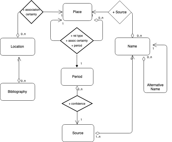
The main entity of the Gazetteer of Ancient Arabia’s conceptual model is the Place
(). The Maparabia Gazetteer adopts the definition of
place disseminated by the project Pleiades (), therefore it takes into consideration elements of the
natural and anthropic landscape, entire settlements and individual artifacts,
political, social and cultural entities related to the territory, whether or not
exactly locatable, whether or not their actual relation with the real world can be
ascertained. Each Place record identifies univocally and persistently an
ancient place and is related at least to one Location, that is its geographical
expression, or one Name, that is its onomastic occurrence in an ancient written
source. The relation with a Location or alternately to a Name is the condition of
existence of a Place. A Place may have a physical or cultural-historical relation
with another Place, that can be also chronologically qualified. Relations Location to
Place, Place to Place and Place to Period are qualified by the degree of confidence
of the associations.
Locations may be provided with Bibliography. Names have a link with at least one
Source which witnesses its existence. This assumption, i.e. the acknowledgment of the
source of a name, is central to the model of this Gazetteer and marks the difference
from other similar projects.
Conceptual model of the Gazetteer of Ancient Arabia.
The main source of place names of ancient Arabia, in particular of ancient South
Arabia, is undoubtedly the huge, local epigraphic heritage. As mentioned above,
inscriptions – mainly the ‘monumental’ inscriptions – put great emphasis on detailing
the names of elements of the natural, anthropic, and social landscape, such as
territories, mountains, rivers, settlements, cultivated fields, hydraulic facilities,
public monuments and private buildings (even single parts or rooms of buildings),
kingdoms, tribes and families.
Because of the availability of thousands of already annotated named entities and of
data on archaeological sites, the bulk of data is to be imported from different
systems, above all DASI. To this aim, the web application of the Gazetteer of Ancient
Arabia includes a module importing data from the DASI web APIs. On the other hand, a
data entry module has been developed in order to enrich with editorial content data
already imported into the database and to include information that has not yet been
encoded. For instance, Names and Sources, in particular those pertaining to the
Arab-Islamic tradition, which are rarely available in digital format, can be added
through the data entry module. A module exporting data completes the system
architecture, allowing to expose Place records, being the other entities nested
within, in JSON-LD format.
Importing data from DASI
Records and portions of texts are the main elements extracted from DASI system, which
is a hybrid system (see the paragraph on the DASI archive, ). Prior to the import of data from DASI, an accurate mapping of fields has
been performed. Importing criteria are adjusted to the type of Places occurring in
DASI: archaeological site corresponding to an ancient settlement; modern site not
identifiable with a place mentioned in ancient sources; monument related to an
archaeological site; territorial entities mentioned in epigraphs.
As regards DASI records, the following ones are those imported into the
Gazetteer:
Sites, mapped into the Location records. One Site corresponds to one Location,
whereas Monuments related to Sites are mapped in separate Locations. Location
items cannot be modified; therefore, users must perform changes to content in
DASI and then run a new import work. One Place record is automatically created
for each Location record; whereas the place type is filled out according to the
mapping criteria (), the remaining fields must be
enriched, as the automatic creation is aimed at the first population only.
Epigraphs, mapped into Source records. Each Name inherits the relation with the
epigraphs which it occurs in. Sources are not editable, but new records can be
added.
Periods are imported into the vocabulary of the same name. Furthermore,
relations between Sources and Periods are automatically created, according to
the chronology of the Epigraph records of DASI. Periods can be changed and
added, and relations with Sources and Places can be multiplied, as many are the
(historical, linguistic, cultural, etc.) parameters that can be taken into
consideration when dating inscriptions and places. However, users have the task
to verify the coherence of chronologies, so that relations are consistent.
Place type
DASI Site / Name type
archaeological site
DASI Site > ancient name = unknown AND modern name ≠ unknown
building <ancient>
Name type = building / sacred place
environmental element
geographic area <modern>
DASI Site > ancient name = unknown AND modern name = unknown AND
region ≠ unknown
kingdom
monument <modern>
DASI Site > monument
settlement <ancient>
DASI Site > ancient name ≠ unknown
social / administrative entity <ancient>
Name type = tribe
Name type = nisbe
Mapping of the Place type for automatic creation of Place
records
As regards the textual elements, the Gazetteer retrieves items from the DASI Word
List, limited to those enclosed by <placeName><placeName> and
<orgName></orgName> tags, plus the <rs></rs> tag encoding the
nisbe, i.e. the adjective describing a relation with territorial and/or social
entities (e.g. Roman, Italian, etc.). Each pair, onomastic item plus EpiDoc compliant
tag of the DASI Word List, is used to create one instance of the entity Name of the
Gazetteer (). This inherits also the relation with the
DASI epigraphic source it is attested in, just as Source inherits the Period it is
dated to in DASI.
DASI EpiDoc compliant tag
Name type
<placeName></placeName>
toponym
<placeName type="sanctuary"></placeName>
sacred place
<placeName type="building"></placeName>
building
<rs type="nisbe"></rs>
nisbe
<orgName type="tribe"></orgName>
tribe
Values of the field name type populated from DASI
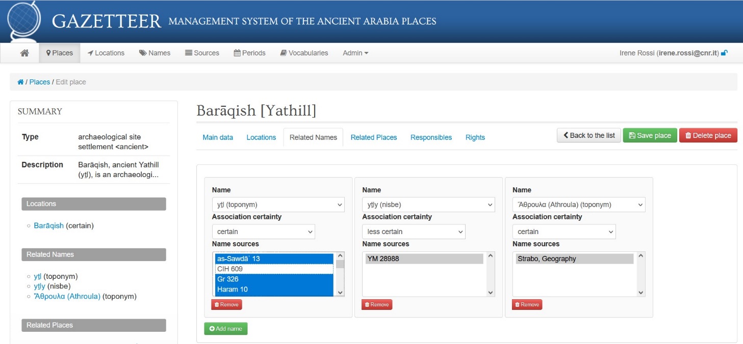
Case-study: Barāqish/Yathill
The example of the place ‘Barāqish’, ancient yṯl (conventionally vocalised
Yathill), illustrates the conceptual model and the functioning of the Gazetteer’s data
entry interface, as regards both the manipulation of DASI-imported data and the addition
of new information.
Location
Barāqish, as an ancient South Arabian archaeological site located in north-western Yemen,
is described by a Site record in DASI [http://dasi.cnr.it/sit-243]. Data imported from this record (country,
coordinates, coordinates accuracy, type of site, structures, location and toponymy,
history of research, general description and chronology) and from the linked
Bibliography records of DASI, populate the Location record of the Gazetteer, that
cannot be manipulated.
Name
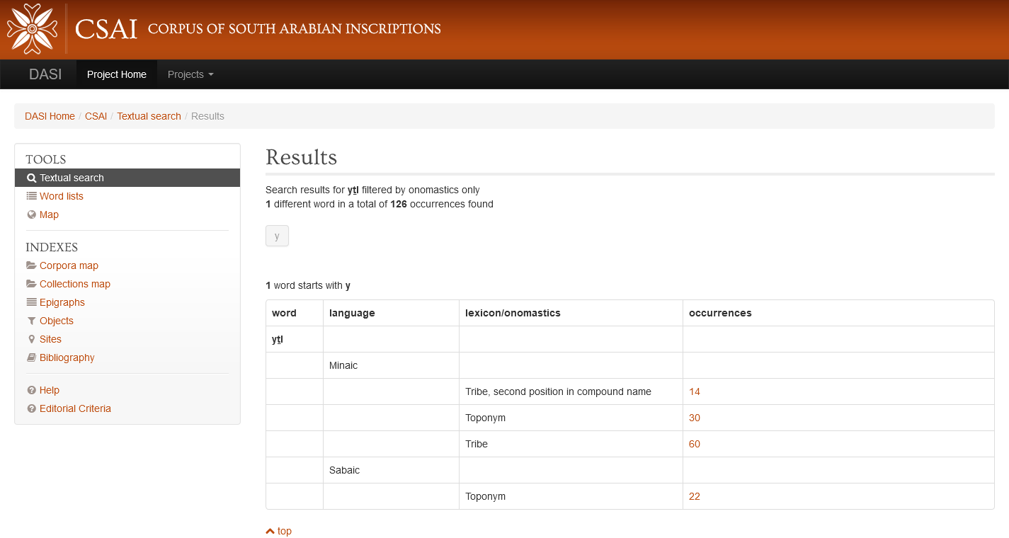
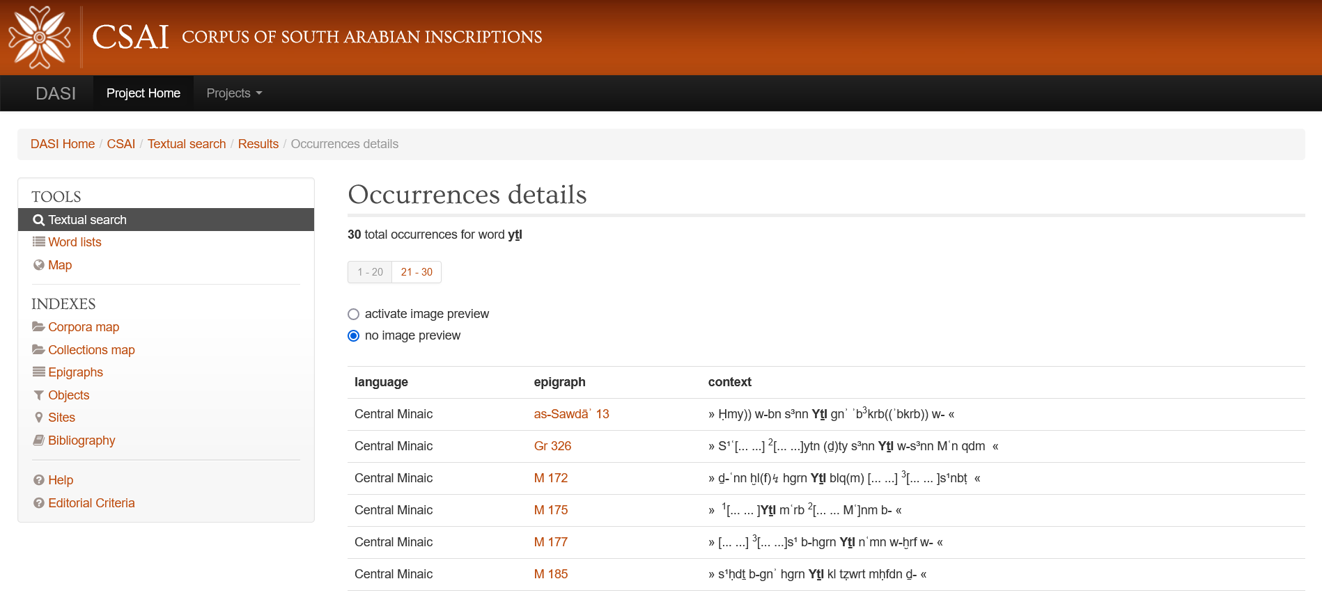
The ancient city of Yathill is mentioned as yṯl <placeName> in 25
Minaic inscriptions encoded in DASI for a total of 30 occurrences, and in 11 Sabaic
inscriptions for a total of 22 occurrences (, ).
List (partim) of the occurrences of the toponym yṯl, annotated as a
<placeName>, in the Minaic inscriptions.
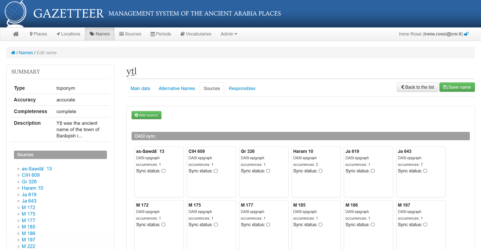
Based on this toponym, the Gazetteer is automatically provided with a corresponding
Name record, which can be enriched in the Gazetteer with comments and information
regarding the language(s) of its occurrences, the accuracy and completeness of
transcription, and links with alternative appellations, such as different spellings
of the name ().
Name-to-Name relation
This is not the case of yṯl, but heterography frequently occurs in the
Semitic inscriptions, for instance in words with a long vowel (mater
lectionis)which can be spelled in both their scriptio plena
and defectiva (e.g. Mrb vs Mryb for the ancient
name of the Sabaean capital). Alternative appellations are managed at the
Name-to-Name relation level, in that the two Name records are associated to
each other as alternative names.
Name record 'yṯl' in the Gazetteer, showing the relations with the Sources
attesting the name.
Source
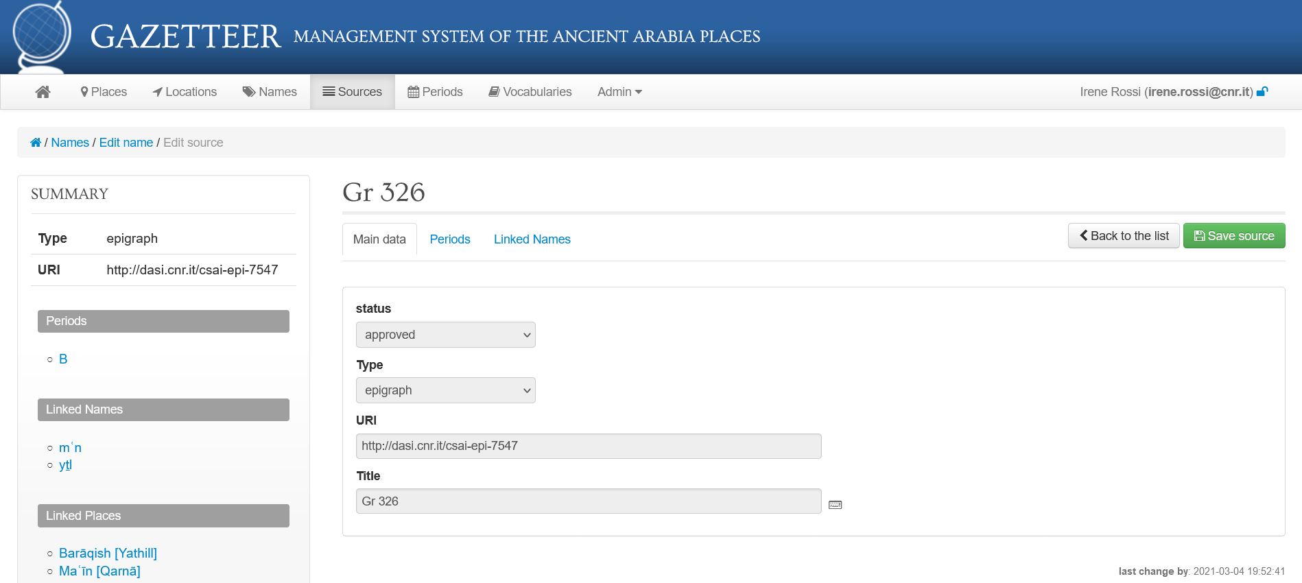
For each inscription featuring at least one occurrence of the toponym yṯl,
the Gazetteer is automatically enriched with a Source record (e.g. Gr 326, ), deriving from DASI the relations with the Names it
attests, besides information such as the epigraphic siglum, the chronology (Period)
and the URI of the corresponding DASI record [http://dasi.cnr.it/csai-epi-7547]. As
one inscription may feature more than one onomastic item concerned with the
Gazetteer, each Source record in the Gazetteer is linked to the Name records of all
the relevant named entities its text contains. For instance, Gr 326 also mentions the
toponym mʿn (modern Maʿīn, the ancient capital of the Minaean kingdom also
governing Yathill; see ‘Linked names’ in ).
Main tab of the Source record 'Gr 326' in the Gazetteer, linked to the
Name record 'yṯl'.
Period
Chronological information on each inscription is described by means of the Source’s
relation with one or more Period records (see :
‘Periods’). These relations are imported from DASI, where a chronological grid for
the Ancient South Arabian corpora, organised in broad periods, is applied to the
inscriptions (Period ‘B’ roughly spans the second half of the first millennium BCE).
However, the Gazetteer also allows to manually enter new Period records and to relate
more than one Period to one Source. To the aims of the Gazetteer, this is useful for
instance when a source is datable to a narrower chronological range with respect to
DASI grid’s periods, or to a different periodization, especially if the Source record
itself is not automatically imported from DASI but created from scratch in the
Gazetteer as in the case of Classical sources.
New records
In fact, one essential feature of the Gazetteer is the possibility of entering new
Name, Source and Period records, besides those imported from DASI. This makes the
Gazetteer an open system: on the one hand it draws from an annotated corpus such as
DASI all the already available information, avoiding manual re-entering of data, but
on the other hand it remains expandable beyond the limits of its main source corpus.
This allows to record the names of the geographical entities comprised within the
scope of the Maparabia Project, be they attested in further linguistic corpora of
inscriptions (from Arabia and beyond, e.g. Greek, Latin, Aramaic, North Arabian
etc.), or in other kinds of sources, above all Classical and Arab-Islamic literature.
For instance, a new Name record was created in the Gazetteer, dealing with Yathill’s
Greek toponym Ἄθρουλα, derived from Strabo’s Geography (16, 4, 24). The latter
constitutes in its turn a newly entered Source, assigned with a proper Period
(1st century BCE).
Place
As the archaeological site of Barāqish corresponds to the ancient city of Yathill,
both the Location and the Name records are connected to the Place Barāqish [Yathill].
Place is fully editable in the Gazetteer, precisely because it is the main container
of new information within the system. It can be assigned one or more types (e.g.
Barāqish is both an archaeological site and an ancient settlement), it can be
provided with external matches in the case it is recorded in other gazetteers (e.g.
Pleiades for the Ancient World: https://pleiades.stoa.org/places/39300), and it can be textually described in
order to summarise its main features ().
Main tab of the Place record 'Barāqish [Yathill]' in the
Gazetteer.
Place-to-Name relation
By means of relations, the Place aggregates the other relevant kinds of data
registered in the Gazetteer, which complete its description. The link with one or
more Location and Name records can be enriched with information on the association
certainty. Each Name carries the assumed relation with the Sources it is mentioned in
and, consequently, the Period of its attestation, thus providing the complete
spectrum of the variations in the onomastics of a given Place, depending on the
language and time of attestation.
One central challenge in the design phase of the system was the management of
homograph names in what concerns their relation to Places. Homograph names of sites
and tribes are not extremely frequent, but there is a considerable number of them
even in the Ancient South Arabian corpus alone. Homograph names of elements of the
natural environment or of buildings or sacred spaces are even more common. For
instance, there is proof that there were at least two sanctuaries of the god Almaqah
named Awwam (ʾwm): one was the main Ancient South Arabian confederal
sanctuary in the surroundings of the capital Maʾrib, the other one was located in a
peripheral area of the Sabaean kingdom. Another example regards the several tribes
named Bakīlum: in order to distinguish among themselves, already in ancient times a
specification indicating the city of origin was sometimes added to the name
bklm (e.g. bklm ḏ-mrymtm, the ‘Bakīlum of (the city of)
Maryamatum’), but this is not always the case. Each pair ‘name-form + onomastic tag’
in DASI Word List is imported in the Gazetteer as a distinct Name; this means that
the same name-form which is marked-up by different tags (e.g. the toponym
yṯl <placeName> and the name of tribe yṯl <orgName
type="tribe">, ) is treated as two separate Name
records. On the other hand, DASI mark-up does not disambiguate between homograph
names having the same tag; the identification of named entities is precisely one of
the aims of the Gazetteer. In order to do so, a functionality of the interface was
implemented, which allows to dissociate specific Sources of one Name in the latter’s
relation with a Place, by de-selecting the irrelevant Source entries (e.g. the
inscription CIH 609 in ).
Management of Place-to-Name relations in the Gazetteer, with (de)selection
of non-pertinent Sources.
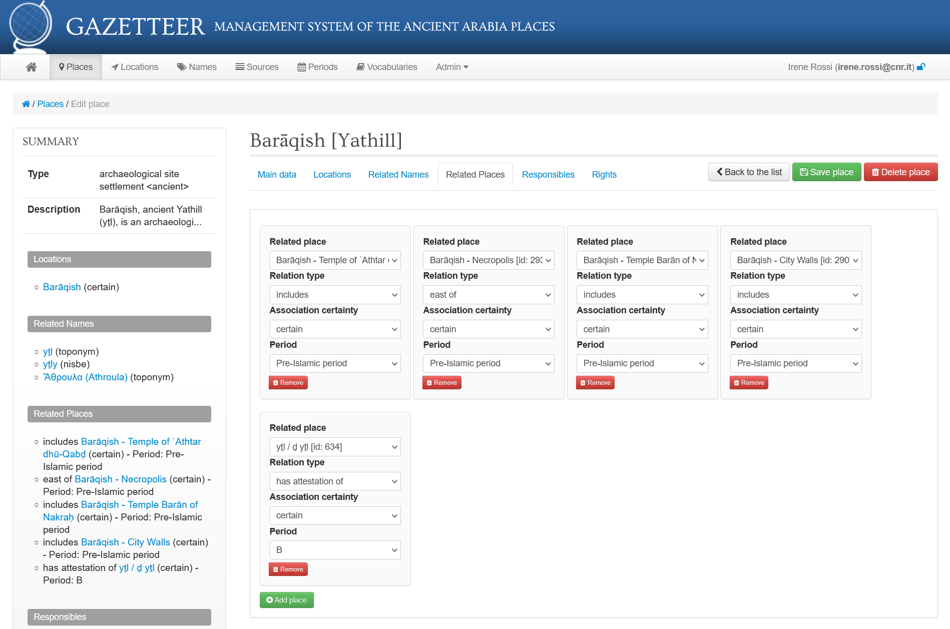
Place-to-Place relation
The relation Place-to-Place allows to draw links between ancient settlements having,
for instance, a relationship of geographic proximity; moreover, it records the is
part of/includes relationships between a Place of type archaeological
site and a Place of type monument. This kind of relation is especially
relevant as most of these monuments are mentioned with their names in the epigraphic
sources, such as the temple of the god Nakraḥ in Barāqish, named Barān (brn)
().
Another kind of Place-to-Place relation is the one between the Place of type
settlement and the Place of type social / administrative entities.
For instance, yṯl ‘Yathill’ (with its alternative name ḏ yṯl
meaning ‘the one of Yathill’) is also the appellation of the tribe (<orgName
type="tribe"></orgName>, ) based in the city of
Yathill; therefore, a Name and a Place records are created for this tribe. The Place
record of the tribe yṯl / ḏ yṯl (type: social / administrative
entity) can be linked to the Place Barāqish [Yathill] (type: settlement) (), and to any further ancient settlements it might have
been connected with.
Management of Place-to-Place relations in the Gazetteer, including relations
with Place-types 'monument' and 'social / administrative entity'.
Issues in data reuse
The dependence from other repositories clearly underlines that the Gazetteer is
conceived as a tool of reuse, exploitation and enhancement of sources, in particular
textual sources, already digitized.
Limitations and opportunities
Precisely the selection of the marked elements has brought out issues regarding the
reuse of encoded texts. According to the encoding criteria established for DASI,
individual onomastic elements can occur within onomastic groups: eponyms (<rs
type="eponym"></rs>), compound names (<rs type="complex"></rs>),
nominal groups (<rs type="nominalGroup"></rs>), and signatures (<seg
type="signature"></seg>). DASI Word List indexes single onomastic elements
regardless of the onomastic groups they are embedded in. This poses problems, in
particular, in compound names whose aim is to define unique onomastic entities
without distinguishing single components.
There is a scientific issue, underlying this problem, that has no solution in itself.
The objective of DASI project, indeed, was the achievement of the digital edition of
the pre-Islamic Arabian epigraphic heritage. Moreover, the linguistic study of the
inscriptions has been one main aim of the encoding process since the first phases of
the project, going back to the end of the 1990s. The Gazetteer,
instead, intends to exploit those digital editions for specific research aims, one of
them being the study of ancient toponyms. Since no encoding work can envisage an
unlimited set of phenomena to be codified for any possible future use, technical
solutions must be devised.
For instance, the site in Saudi Arabia now called Qaryat al-Fāw received several
appellations in the Ancient South Arabian inscriptions, all to be referred to the
same place:
qryt: <placeName>qryt</placeName>
qrytm: <placeName>qrytm</placeName>
qryt ṭlw, probably to be interpreted as ‘Qaryat the Red’: <rs
type="complex"><placeName n="1">qryt</placeName> <placeName
n="2">ṭlw</placeName></rs>
qrytm ḏt khlm, lit. ‘Qaryat that of Kahl’ (Kahl being the local god):
<rs type="complex"><placeName
n="1">qrytm</placeName>< placeName
n="2">ḏt</placeName>< placeName
n="3">khlm</placeName></rs>.
This results in qryt, qrytm, ḏt, khlm and
ṭlw being indexed as separate onomastic items corresponding to each of
the <placeName> elements in DASI Word List, and would
therefore generate separate Name records in the Gazetteer. While this processing of
words was based on DASI’s interest towards linguistic annotation, the Gazetteer has
the different objective of identifying and disambiguating the geographic/territorial
entities designated by specific names, thus associating the names qryt,
qryt ṭlw, qrytm and qrytm ḏt khlm with one single Place
entity.
To overcome this idiosyncrasy between the two systems, the Gazetteer import module
has been designed so that compound names including <placeName></placeName>
and <orgName></orgName> tags are reconstructed and mapped into Name
records. After a survey of the compound names encoded, a set of conditions the import
module must check have been established. Since each text is considered a sort of
matrix and each word has a position defined by the intersection between a line and a
column, only onomastic elements that comply with all of them are aggregated in a
compound name:
they are attested in the same inscription,
at the same line
in linear sequence (order of the occurrence)
they belong to the same name type
they are placed on consecutive columns (except for clitics that have the same
position of the word they are connected to).
Synchronization issues
The Gazetteer architecture, in that it depends from a different system, has raised
also synchronization issues. More generally, synchronization and versioning are
issues to be faced when reusing data.
The Maparabia gazetteer has a one-direction synchronization: changes to contents in
the Gazetteer do not turn back to DASI, whereas any change to DASI may cause updates
in the Gazetteer, by addiction or rewriting, in particular to editable fields. The
choice of not simply exporting data from DASI into the Gazetteer una tantum,
but of synchronizing the two systems is due to the consideration that DASI, which is
the base source of the Gazetteer’s data, is not a closed project: not only are
corpora constantly updated with new epigraphic material, but editions are also
corrected on the basis of improved readings and new linguistic and cultural
interpretations. We deemed it essential that the evolving life of DASI data could
implement the Gazetteer, in order to make of it an always up-to-date tool.
In order to achieve this goal, the Gazetteer keeps tracks of the updates to the
contents and allows to control the results of the import works, by excluding records
from updates. There is no proper control panel, but this is distributed among the
sections corresponding to the Gazetteer entities. Indeed, each section is provided
with a list of previews that users can filter and browse by sync status. The list is
updated when an import work is accomplished and shows changes that
were performed on DASI and are likely to affect contents of the Gazetteer: creation
and deletion of onomastic items of the Word List and Site records, but also
modifications that cause changes in Names, Locations and their relations; creation
and deletion of Epigraph records that affect Sources; amendments to the encoded
texts that modify occurrences of onomastics; creation, modification and deletion of
Periods.
This display method replaces notifications. Moreover, changes are finally transferred
into the Gazetteer, only after a manual validation is carried out. Each record
preview is provided with a circle, the icon that represents the sync status, and a
button to be clicked for validation. The colors of the circle are codified according
to the sync status:
green: a new record was created in DASI and has just been imported into the
Gazetteer. Users, once the record itself is checked and possible relations are
evaluated, are invited to validate import. Thus, the circle becomes empty
red: the record has been deleted in DASI, but is still present in the
Gazetteer. Once users have checked its relations, it can be definitively
deleted by the basket icon
blue: the corresponding record in DASI has been recently updated. Users are
required to take note and validate the update; afterward the blue circle
becomes empty
empty circle: no action is required.
Users have therefore active role: since no change becomes permanent without their
intervention, they are stimulated to enrich contents by integrating Name files,
creating new Places and relations among entities.
Not only records are provided with sync status. The relation Name to Source, namely
the occurrences of names in a particular inscription, are subject to
synchronization: if even one of the occurrences is modified, the overall status
changes according to the color codification above. Validation, however, is not
required. It is aimed only at drawing the attention to changes and their potential
consequences.
For instance, if a new inscription attesting ns2n <toponym> (the ancient name of the site of as-Sawdāʾ in northern
Yemen, conventionally vocalized Nashshān) is added in DASI, an import work will
create a new Source record (green) in the Gazetteer for that inscription. As the Name
record ns2n <toponym> was already present in the Gazetteer because it is already
attested from other sources, it will appear in the list of Names provided with a blue
circle (): this indicates that a synchronization change
has happened to the Name record.
Example of change in the circular icons’ colours, reflecting
synchronization updates.
This change precisely regards the addition of a new Name-to-Source relation, which
will be indicated by a green circle in the ‘Sources’ tab of the ns2n <toponym> Name record; the ‘old’ (i.e. already approved) Name to
Source relations feature an empty circle instead (cf. e.g. ). The user is called to validate the changes by means of the dedicated button.
The addition of Sources has also consequences with respect to the Place-to-Name
relation, as the user has to confirm that the name-form in that specific Source is
correctly attributed to that Place (the automatic selection being disabled because of
potential homograph Names; cf. ).
If, instead, one of the ‘old’ Name-to-Source relations is broken because, on the
basis of a new reading or interpretation, the spelling of the only one occurrence of
the toponym in a specific inscription is changed (e.g. from the toponym […
n]s2n to the nisbe [… ʾs2]s2n ‘the Nashshānites’), the Name-to-Source relation will feature a red
circle. If that Source features instead further occurrences of ns2n <toponym>, the circle will be blue.
Finally, if a name is only known by one occurrence in one DASI inscription (i.e. the
Name record is linked to only one Source) and the name-form is changed in (or the
name is completely deleted from) that inscription, not only the Name-to-Source
relation will be displayed in red, but also the Name record itself. If the Gazetteer
user agrees with such editorial changes in DASI, after having deleted the relevant
relations between records, he/she will be also able to delete the Name record in the
Gazetteer.
Conclusions
In conclusion, if the historical and cultural domain of the Maparabia Gazetteer – i.e.
Ancient Arabia – is its main peculiarity, its added value, compared to the other
gazetteers of the ancient world, is the direct and ‘living’ bond with the annotated
epigraphic corpus providing it with the direct sources of ancient toponymy. The core
data of the Gazetteer results automatically from the mass digitization of the direct
written heritage of pre-Islamic Arabia conducted during the DASI project, according to
guidelines that have established themselves as proper standards in the digital
epigraphy field, and applying the best practices that were subsequently formalized under the
label of FAIR principles (). DASI records, provided with
URIs, are exposed in standard formats (oai_dc, EpiDoc, EDM) in an OAI-PMH repository,
thus allowing different projects to access and use its data.
Standards and best practices that were observed have ensured the effective and easy
reuse of texts, even though the scientific objectives of the Gazetteer are significantly
different from the original purpose of the digitization and scope of use of the digital
edition. Imported data can be enriched in the Gazetteer with additional details arising
from the thorough study of the sources and the effort to systematize identification and
relations. The instances of the main entity Place, in fact, are the only ones that must
be created from scratch, requiring the editorial intervention to disambiguate, identify
and circumscribe an ancient place. As well as the creation of the relation Place
to Place, this is the step of the workflow the scientific reflection focuses on, and the
editorial responsibility is more significant.
The export module of the Gazetteer allows to expose Place records, being the other
entities nested within, in JSON-LD format. Each Place item is identified with a URI and
is released under open license. This is consistent with the philosophy that has allowed
the Gazetteer itself to be created and is expected to increase dissemination through
aggregation and linking with further gazetteers, and therefore with archaeological,
textual and geographic data, pertaining to different chronological and cultural contexts
(;).
Acknowledgements
The research leading to this paper received funding by the French National Research
Agency in the frame of the project Maparabia (ANR-18-CE27-0015, PI J. Schiettecatte,
2019-23). We wish to acknowledge the contribution of Dr. Alessandra Lombardi to the
records of the Gazetteer of Ancient Arabia pertaining to the case-study described in
this article.
References
Avanzini, Alessandra, Annamaria De Santis, and Irene Rossi. 2018. ‘Encoding,
Interoperability, Lexicography: Digital Epigraphy through the Lens of DASI
Experience’. In Crossing Experiences in Digital Epigraphy: From Practice to
Discipline, by Annamaria De Santis and Irene Rossi, 1–18. Warsaw: De
Gruyter Open Poland. https://doi.org/10.1515/9783110607208-002.
Avanzini, Alessandra, Annamaria De Santis, Daniele Marotta, and Irene Rossi. 2014.
‘Between Harmonization and Peculiarities of Scientific Domains. Digitizing the
Epigraphic Heritage of Pre-Islamic Arabia in the Project DASI’. In Information
Technologies for Epigraphy and Cultural Heritage. Proceedings of the First
EAGLE International Conference, edited by Silvia Orlandi, Raffaella
Santucci, Vittore Casarosa, and Pietro Maria Liuzzo, 69–93. https://doi.org/10.13133/978-88-98533-42-8.
Avanzini, Alessandra. 2016. By Land and by Sea: A History of South Arabia
before Islam Recounted from Inscriptions. Arabia Antica 10. Roma: «L’Erma»
di Bretschneider.
De Santis, Annamaria, and Irene Rossi, eds. 2018. Crossing Experiences in
Digital Epigraphy: From Practice to Discipline. Warsaw: De Gruyter Open
Poland. https://doi.org/10.1515/9783110607208.
Elliott, Tom, and Sean Gillies. 2010. ‘Digital Geography and Classics’. In
Changing the Center of Gravity: Transforming Classical Studies Through
Cyberinfrastructure, edited by Melissa Terras and Gregory Crane, 223–62.
Piscataway: Gorgias Press. https://doi.org/10.31826/9781463219222-013.
Elliott, Tom, Gabriel Bodard, Elli Mylonas, Simona Stoyanova, Charlotte Tupman,
Scott Vanderbilt, and et al. 2007-2017. ‘EpiDoc Guidelines: Epigraphic Documents
in TEI XML (Version 8)’. http://www.stoa.org/epidoc/gl/latest/.
Isaksen, Leif, Rainer Simon, Elton T.E. Barker, and Pau de Soto Cañamares. 2014.
‘Pelagios and the Emerging Graph of Ancient World Data’. In Proceedings of the
2014 ACM Conference on Web Science (WebSci ’14), 197–201. New York, NY,
USA: Association for Computing Machinery. https://doi.org/10.1145/2615569.2615693.
Schiettecatte, Jérémie. 2011. D’Aden à Zafar. Villes d’Arabie Du Sud
Préislamique. Orient & Méditerranée. Archéologie 6. Paris: De
Boccard.
Shaw, Ryan. 2016. ‘Gazetteers Enriched: A Conceptual Basis for Linking Gazetteers
with Other Kinds of Information’. In Placing Names: Enriching and Integrating
Gazetteers, edited by Merrick Lex Berman, Ruth Mostern, and Humphrey
Southall, 51–63. Bloomington: Indiana University Press. https://doi.org/10.2307/j.ctt2005zq7.
Southall, Humphrey, Ruth Mostern, and Merrick Lex Berman. 2011. ‘On Historical
Gazetteers’. International Journal of Humanities and Arts Computing 5
(2): 127–45. https://doi.org/10.3366/ijhac.2011.0028.
Stein, Peter. 2020. ‘Ancient South Arabian’. In A Companion to Ancient Near
Eastern Languages, edited by Rebecca Hasselbach-Andee, 337–53. John Wiley
& Sons, Ltd. https://doi.org/10.1002/9781119193814.ch18.
Tupman, Charlotte. 2021. ‘Where Can Our Inscriptions Take Us? Harnessing the
Potential of Linked Open Data for Epigraphy’. In Epigraphy in the Digital Age.
Opportunities and Challenges in the Recording, Analysis and Dissemination of
Inscriptions, edited by Isabel Velázquez Soriano and David Espinosa
Espinosa, 115–28. Oxford: Archaeopress.
Wilkinson, Mark D., Michel Dumontier, IJsbrand Jan Aalbersberg, Gabrielle
Appleton, Myles Axton, Arie Baak, Niklas Blomberg, et al. 2016. ‘The FAIR Guiding
Principles for Scientific Data Management and Stewardship’. Scientific
Data 3 (1): 160018. https://doi.org/10.1038/sdata.2016.18.
This article is the result of a joint effort of all the authors. Only for academic purposes, part 4 (The Gazetteer of Ancient Arabia) is specifically attributed to A. De Santis, and part 5 (Case-study: Barāqish/Yathill) to I. Rossi.
DASI corpus is consultable through indexes and search tools at [http://dasi.cnr.it/]. DASI is the output of a five-year
research project funded by the ERC from 2011 to 2016 (GA 269774; PI: Alessandra
Avanzini, University of Pisa). It is currently maintained at the Consiglio Nazionale
delle Ricerche.
Maparabia is a 5-year project funded by the French National Research Agency (ANR-18-CE27-0015), which
encompasses a variety of fields of research: history, archaeology, epigraphy,
linguistics, palaeography, geomatics, and geography. The fifteen members of the
project come from four laboratories dedicated to pre-Islamic Arabia: CNRS-Orient
& Méditerranée (Paris), CNRS-Archéorient (Lyon), Dipartimento di Civiltà e Forme
del Sapere of the University of Pisa, and CNR-ISPC (Milan) [ http://www.orient-mediterranee.com/spip.php?article4002 ].
The focus on the linguistic description of the texts and the pioneering venture of
the project in the realm of the digitization of Ancient Arabian epigraphy informed
the choices made in the original encoding of the onomastic phenomena. This has
sometimes brought about legacy issues with which it was not always possible to cope
within the scope of DASI project. For a detailed description of DASI encoding and
the discussion of such limitations, see .
Going into deeper detail, the occurrences of the entry (word-form) qryt in
the Word List are grouped into sub-entries: one described as a ‘toponym’ (for the
occurrences of qryt alone) and one as a ‘toponym, first position in compound
name’ (for qryt ṭlw, and potentially for any other compound toponym having
qryt as its first element). The case of qrytm ḏt khlm is even
more complex, as one of its <placeName> elements, namely ḏt, also
occurs in other toponyms, such as ḏt ġylm (modern Hajar Ibn Ḥumayd in
Yemen).
![Main tab of the Place record 'Barāqish [Yathill]' in the Gazetteer.](https://umanisticadigitale.unibo.it/article/download/13681/version/12004/13771/53194/image6.png)